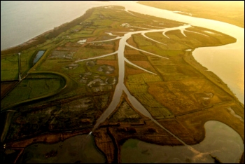
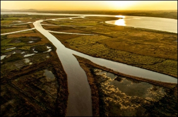
High tides have been allowed to deliberately flood the Steart peninsula coastline near Burnham-On-Sea this week in a £20 million scheme to reduce the loss of inter-tidal habitat.
Around 250 hectares of low-lying land near the mouth of the River Parrett are now under water for the first time after the completion of a newly excavated 200-metre gap in the coastal embankments.
Steart Marshes, as the land is now known, is estimated to replace half the anticipated loss of habitat, as well as reducing the risk of flooding on the Somerset Levels.
The joint project between the Wildfowl & Wetlands Trust and the Environment Agency has cost around £20 million.
The scheme uses the shallow gradient and coarse vegetation of the saltmarsh to absorb wave energy naturally which helps to protect local villages from storm surges, and protect the newly constructed flood banks from erosion so that they last longer.
Some, including Bridgwater MP Ian Liddell-Grainger have condemned the scheme as a “grandiose scheme-cum-nature reserve.” He criticised the creation of a scheme with “unproven” benefits while for years dredging of the rivers Parrett and Tone was neglected.
But the Wildfowl & Wetlands Trust’s Chief Executive, Martin Spray, has defended the scheme and said: “We need to be brave and bold if we are going to deal with the impacts of climate change. WWT Steart Marshes proves you can protect homes and businesses by using wetland technology that works with nature, not against it. Climate change is here now. Last winter was the wettest on record and we suffered the worst storms for 20 years. I want to give full credit to the villagers of the Steart Peninsula for getting behind this idea, helping to shape it and helping to save the peninsula from being lost to rising sea levels.”
 Richard Cox at the Environment Agency added: “Over 200km of coastal banks around the Severn Estuary reduce flood risk to more than 100,000 homes and businesses, a benefit valued at £5 billion. There is an ongoing need to maintain these structures.”
“The Steart project will directly protect homes, businesses and the surrounding infrastructure. The National Grid power lines into Hinkley Point power station are a key element of the national infrastructure protected by the scheme.”
“Saltmarsh is a natural flood risk management scheme. Like coral reefs or mangroves in the tropics, saltmarsh takes energy out of the tide and reduces wave height.”
“At Steart Marshes the new flood embankments are set behind 100s of metres of saltmarsh which will reduce the impact of high tides on them, bringing down maintenance costs and prolonging their life.”
Half a million cubic metres of soil were dug and moved to create new and improved flood banks.


