Hot summer weather is set to be replaced by violent thunderstorms on Saturday, the Met Office has warned.
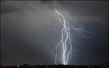
The Met Office has today (Friday) upgraded its warning for heavy rain, lightning and thunder from yellow to an amber warning as this week’s mini-heatwave is predicted to set off major storm activity.
This week’s sunny weather, pictured above, has seen soaring temperatures – but these will come to an end on Saturday.
Torrential rain and storms are predicted to cause localised flooding and strong winds on Saturday, say forecasters.
 There will be areas of heavy and thundery showers developing over the area from early on Saturday before moving northwards during the day.
A spokesman for the Met Office said: “The development of these is uncertain but where they do form some torrential downpours are possible with frequent lightning, hail and locally strong gusts.”
“Significant flooding is possible where these do occur from surface water as well as small, fast responding watercourses. The frequent lightning, hail and strong gusts could also be an additional hazard.”
The spokesman added: “The public should be aware of the risk of disruption from any of these elements. This alert is likely to be updated in the coming days. Following a build of very warm and humid air from mid-week onwards there is the potential for the development of large thunderstorms over England and Wales from early on Saturday.
“In this situation large amounts of energy are available in the atmosphere and this coupled with high moisture content can lead to torrential downpours along with frequent lightning activity, hail and locally strong gusts.”