Sat-nav systems have been blamed for a big increase in traffic passing through residential areas of Burnham-On-Sea to reach Brean, raising safety fears.
Town councillors have this week heard from concerned residents who want new road signs introduced to direct traffic along normal routes.
Cllr Ken Smout told a meeting of the council: “Over the summer months and at busy holiday periods there has been a big increase in motorists using Stoddens Road to reach the holiday parks at Brean and Berrow. They’re relying on their sat-nav systems to choose the route rather than looking at road signs, which is a worry.”
Peter Little, a resident in Stoddens Road, told Burnham-On-Sea.com: “Many sat-navs are now instructing all traffic heading to Brean, Berrow and Burnham North from the M5 junction to leave Queens Way and follow Edithmead Lane and Stoddens Lane into Stoddens Road for its entirety to the T-junction with Berrow Road, instead of following the main road via the Tesco roundabout to the Esso roundabout and along Berrow Road.”
“This route includes the weak and narrow Edithmead Railway Bridge with its weight limit and, consequently, there has been a considerable increase in traffic along Stoddens Road, also an increased danger on the corner near the BASC Ground. The Stoddens Road and Berrow Road junction is becoming a major junction and will soon merit traffic lights.”
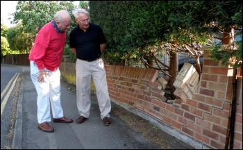 He added: “Over the years there have been many traffic incidents in Stoddens Road, where vehicles have left the road and driven into ditches, or driven into walls and fences, causing extensive damage to properties.”
Cllr Andy Brewer told Burnham-On-Sea.com that sat nav systems have also been causing problems in other areas of Burnham. “I’ve seen motorists trying to reach Burnham Holiday Village via Lundy Drive and Atlantic Crescent using directions on their sat nav systems. While that may be the quickest route on a map, in fact there’s no road access onto the holiday park that way at all!” he said.
Town councillor Phil Harvey said at this week’s council meeting that “rather more signs being introduced, you have to wonder whether a new road should be built to access Brean instead.”
Peter Elliot, a spokesman for Somerset County Council, said they are aware of the concerns. He added: “We do consider changes to signage when we are approached by a town or parish council. We will then visit the site to check the suitability of the current signs and consider whether any improvements can be made.”
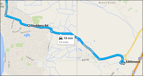
Pictured: A sat-nav system in use (photo Tristan Ferne), and above, Cllr Smout inspecting a damaged wall in Stoddens Road after a collision; and below, a Google map showing a route to Brean from the M5 via Stoddens Road and Stoddens Lane rather than along Queen’s Drive and Love Lane