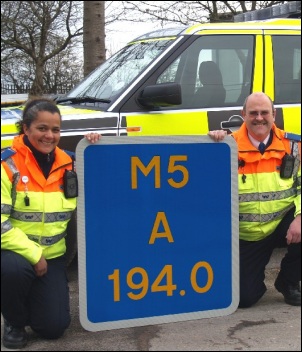
Brand new signs designed to help drivers pinpoint where they are if they break down or want to report a problem on the M5 motorway are being installed in the Burnham-On-Sea area.
The new roadside driver location signs are currently being introduced along the M5 between junctions 15 to 31 and the information on them will ensure the Highways Agency and other emergency services can reach motorists more quickly.
David Stock, Project Sponsor on behalf of the Highways Agency, said this week: “With many people using mobile phones to call for assistance these days, rather than the motorway emergency phones, it can be difficult to find a caller’s exact location. If road users can tell us what is on the sign nearest to them on the motorway, we can work out where they are if they breakdown or need to report an incident.”
“The new signs will mean the emergency services and Highways Agency Traffic Officers can respond to incidents more quickly and reduce the risk of secondary incidents, congestion and delay to other road users.”
Information given on the signs will be the number of the motorway, a letter A or B which tells the Highways Agency or the emergency services which direction you are traveling in. The figure underneath the letter represents the distance in kilometers travelled along the motorway, which increases as you travel from the start of the motorway.
Work will be carried out during daytime hours and will be carried out in the Burnham-On-Sea area from 13th January to 16th March.
Highways Agency traffic officers Teresa Williams and Nigel Caine are pictured with one of the new driver location signs


